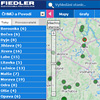
Local Warning Systems
Main menu
- Solutions
- Tap water treatment
- Dispatching accessible via the Internet
- Remote water meter reading
- Monitoring of water leak
- Measurement of qualitative water parameters
- Measurement in Water Supply Network
- Pressures and flows regulation
- Controlling of water pumps and water reservoirs
- Controlling technology of waste purification plants
- Flow processing into charts
- Waste water treatment
- Monitoring of running and technology of WWTP
- Control technology of WWTP
- Measurement of waste water flow
- Dissolved oxygen measurement and aeration blowers control
- Measurement of chemical parameters of water
- Local control of pumping stations
- Remote control of pumping stations
- Root zone waste water treatment plants
- Dispatching accessible via the Internet
- Processing of measured flow data
- Water level monitoring
- Flood warning system
- Environmental monitoring
- Water level and flow monitoring in small water-courses
- Temperature measurement in bore holes and water basins
- Monitoring of soil humidity and temperatures
- Measurement of rain-fall quantity and intensity
- Level measurement in boreholes and remote data collecting
- Measurement of water temperature and conductivity in boreholes
- Measurement of well yield – pumping tests
- Water-level regulation in boreholes
- Capacity and intensity of drainage water
- Thermal balance in ecological constructions
- Meteorological stations
- Relative humidity and air temperature, rainfall, global radiating, atmospheric pressure, speed and direction of wind
- Satellite transfer while the GSM signal is unavailable
- Meteorological stations for agriculture and research institutes
- Extension of meteorological stations about special sensors
- Different type of tower constructions
- Data transfers into the Internet
- Special kinds of graphs for visualization
- Irrigation control systems
- Data collecting and processing
- Data hosting on the server
- Software MOST
- Parameterization of stations via the Internet
- Transferring of measured data into a current dispatcher programme
- Visualization and processing of data
- Data exports from the server into the PC
- Overview reports working-out and printing
- An automatic emails sending
- Types of SIM cards
- Operating costs of the telemetric station
- Industrial applications
- Tap water treatment
- Products
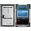
- Monitoring and control units for water supply
- Small telemetric stations and data loggers
- Smart Metering - remote meter readings
- Water level meters
- Hydrostatic level meters
- Radar level meters
- Ultrasonic level meters
- Level gauges for wells, boreholes and reservoirs
- Level float switches
- Equipment for pumping tests of boreholes and wells
- Local Warning Systems
- Flow meters for open channels
- Water quality sensors
- Meteorological stations and measuring sensors
- Accessories for control units and data loggers
- Boxes and cabinets for telemetry and control units
- Gel accumulators, batteries and backup sources
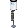
- AC power supplies and battery chargers
- Photovoltaic solar panels
- Antennas and extension cables
- Sensor cables, connectors and connecting expanders
- Communication signal converters and communication cables
- Mechanical mounting elements
- Industrial and residential water meters
- Server software and services
- References
- Support & Download
- About us
- Monitoring
- Datahosting